Funded by the European Commission, EUXDAT project (European e-Infrastructure for Extreme Data Analytics in Sustainable Development) started in November 2017. October 2020 is its last month.
EUXDAT proposes an e-infrastructure, which addresses agriculture, land monitoring and energy efficiency for a sustainable development, as a way to support planning policies. In order to do so, we need to address the problems related to the current and future huge amount of heterogeneous data to be managed and processed.
EUXDAT builds on existing mature components for solving them, by providing an advanced frontend, where users will develop applications on top of an infrastructure based on HPC and Cloud. The frontend provides monitoring information, visualization, different parallelized data analytic tools and enhanced data and processes catalogues, enabling Large Data Analytics-as-a-Service.
EUXDAT will include a large set of data connectors (UAVs, Copernicus, field sensors, etc.), for scalable analytics.
As for the brokering infrastructure, EUXDAT aims at optimizing data and resources usage. In addition to a mechanism for supporting data management linked to data quality evaluation, EUXDAT proposes a way to orchestrate tasks execution, identifying whether the best target is a HPC center or a Cloud provider. It will use monitoring and profiling information for taking decisions based on trade-offs related to cost, data constraints, efficiency and resources availability. During the project, EUXDAT will be in contact with scientific communities, in order to identify new trends and datasets, for guiding the evolution of the e-Infrastructure. The final result of the project will be and integrated e-Infrastructure which will encourage end users to create new applications for sustainable development.
EUXDAT Final Webinar
EUXDAT Pilot Session 1
EUXDAT relevance towards Farm to Fork and Towards a Green Cap. Karel Charvát (CoO)
The Farm to Fork Strategy, s to address the challenges and accelerate the transition to sustainable food systems, to ensure that the economic, social and environmental foundations of food and nutrition security are not compromised for current and future generations. To be possible implement challenging goal of Farm Fork Strategy, there will be necessary to introduce effective knowledge management. We will share our experience, how new technologies can help with implementation of such knowledge management system.
Crop Climate Risk Analysis, Monitoring, and Prediction. Nicoletta Addimando, Christoph Ramshorn (meteoblue)
We combine local climate data with information on a crop’s susceptibility to drought and frost in different growth stages. This allows us to analyse which crops are best suited for a location as it is affected by climate change. We can also monitor crop weather risks as the current growing season unfolds and predict crop weather risks for 5 to 14 days.
Discussion and feedback analysis, Karel Charvát (CoO), Jorge Lopez (ATOS)
EUXDAT Pilot Session 2
EUXDAT relevance towards Achieving Climate Neutrality. Karel Charvát (CoO)
Climate action will be at the heart of the European Green Deal – an ambitious package of measures ranging from ambitiously cutting greenhouse gas emissions, to investing in cutting-edge research and innovation, to preserving Europe’s natural environment. We will explain, how EUXDAT can help manage weather information and how can help to agriculture in mittigation on climatic changes and also how reduce negative influence of Agriculture on clime
Agro-Climatic Zones Scenario. Karel Jedlička, Pavel Hájek (WirelessInfo)
The Agro-climatic classification system allows user to calculate a time and spatial distribution of agroclimatic variables such as Forst dates (Last frost dates/First spring dates), Annual/Seasonal Evapotranspiration and precipitation, Soil temperature, Solar radiation, Growing degree units, Heat stress units or Number of days with optimal growing temperatures based on historical data of ERA5-Land dataset.
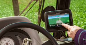
Field Accessibility Tool and its Components. Marcela Doubková (PESSL Instruments)
WORKFLOW is a service for clients that provides them information on field accessibility for their machinery for upcoming 3-5 days. The service is based on iMETOS soil moisture data (from Pessl Instruments), soil moisture forecasted data (Meteoblue), DEM available from Shuttle Radar Topographic Mission (SRTM) as well as state-of-the-art Sentinel-2 data. The output information informs user about field accessibility ranging from ‘not accessible’ to ‘easy accessible with heavy machine’.
Discussion and feedback analysis, Karel Charvát (CoO), Jorge Lopez (ATOS)