Tools developer Ephtracy has Aerialod, a free interactive path tracing renderer for visualising height maps for use in game development or visual effects work.
The software imports height maps in a range of standard formats and converts them into renderable 3D terrain, with customisable lighting, environment fog and camera properties.
Created by the developer of popular free 8-bit voxel art editor MagicaVoxel, Aerialod makes the same interactive path tracing renderer available for visualising height maps.
The software imports maps in a range of standard formats, including PNG or ASC files, and Digital Terrain Models (DTM), automatically generating the corresponding 3D terrain.
Users can then customise the result by adjusting the height scale or vertical offset for the terrain, or choosing a level of detail setting, which progressively voxelises the output.
It is also possible to customise the lighting in the scene by setting the sun position or assigning an HDR environment map; to add environment fog; and to set a range of real-world camera properties.
The 3D terrain can then be rendered as a still image in 8-bit or 16-bit PNG format at a resolution of up to 16,384 x 16,384px, or as a turntable animation.
It is also possible to render albedo and normal maps for the terrain.
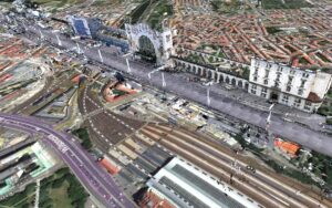
The software is still a work in progress – it’s officially an 0.0.0 release – but early users have been having a lot of fun rendering both real-world satellite data and synthetic height maps.
You can see some of the best images retweeted on Ephtracy’s Twitter feed.
Availability and system requirements
Aerialod is available free for 32-bit and 64-bit Windows only.