
Physical Address
304 North Cardinal St.
Dorchester Center, MA 02124

VeriDaaS, a geospatial solutions company, is planning a high-density LiDAR elevation data collection at a minimum of 30 points per meter (ppm) over the entire State of California in the Spring 2021 as part of the VeriDaaS National Mapping Initiative…
Esri UK announced a new partnership with drone specialists Heliguy to complete its end-to-end drone solution designed for the AEC industry. The final piece in Esri UK’s strategy to offer all parts of the drone workflow, the partnership will provide…
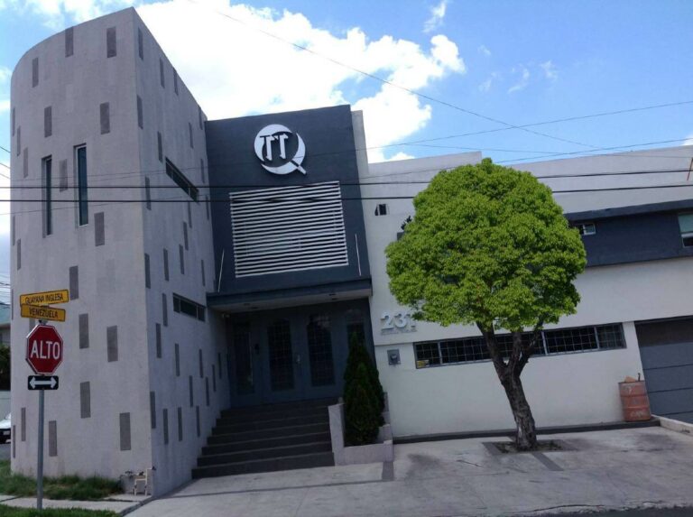
Expanding its presence throughout Latin America, RIEGL is excited to welcome TTQ de Monterrey, based out of Mexico, to the growing base of renowned RIEGL distribution partners. TTQ de Monterrey first started operations in 1994, based out of Monterrey, Mexico.…
Esri Ireland is partnering with aerial mapping company Bluesky International to provide organisations across the island of Ireland with highly detailed geospatial data. The partnership will enable existing and prospective Esri Ireland customers to avail of Bluesky’s premium data resources,…
The report summarizes the outputs achieved in Challenge #2 of the Covid-19 INSPIRE Hackathon during the first part of the event. Number of registered participants: 11 Challenge # 2 Shared Worskpace The final goals of the challenge: Main goal: To…
The report summarizes the outputs achieved in Challenge #1 of the Covid-19 INSPIRE Hackathon during the first part of the event. Challenge #1 Shared Workspace (complete information about activities in the challenge) The final goals of the challenge: Main goal:…
This mid-term report of challenge #3 of Covid-19 INSPIRE hackathon contains the most interesting and valuable achievements, which have been done so far. There are 19 registered participants in our challenge. A collaboration with challenges has been established or being…
The report summarizes the outputs achieved in challenge #4 of the Covid-19 INSPIRE Hackathon during the first part of the event. Number of registered participants: 28 Challenge #1 Shared Workspace (complete information about activities in the challenge) Interconnection with pilot…
Hexagon’s Geospatial division has launched Luciad 2020.1, a significant update to its platform for building advanced location intelligence and real-time, situational awareness applications. Luciad 2020.1 delivers immersive 3D experiences with 360° panoramic imagery support that can be combined with other…
Fugro is mobilising its Rapid Airborne Multibeam Mapping System (RAMMS) to Ontario, Canada, to acquire 3147 km2 of high-resolution bathymetry data over Lake Huron for the Canadian Hydrographic Service (CHS). The survey is expected to last six months from data…
In its research report, “Earth Observation Data & Services Market”, Euroconsult provides in-depth analysis of Earth Observation (EO) satellite systems, commercial EO data, and the value-added services that contribute to the sector. With a global market projected to reach $8…
Topcon Agriculture announces the release of new in-cab displays — XD and XD+ touchscreen consoles — with an upgraded user interface experience — Horizon 5. With Topcon Agriculture Platform (TAP) integration, the consoles are designed to provide farmers with full-feature…
Bentley Systems has announced the winners of the Year in Infrastructure 2020 Awards. The annual awards program honors the extraordinary work of Bentley users advancing design, construction, and operations of infrastructure throughout the world. Sixteen independent jury panels selected the…
Free registration period for the 16th International gvSIG Conference is now open. The conference will be held from Nov 4th to 6th as an online event this year. Conference program is also available on the event website. There will be…
Wessex Water has piloted an artificial intelligence (AI) system for drainage water management plans (DWMPs). The system, which uses Modefrontier simulation software with EnginSoft, took just four days of an engineer’s time and 12 days’ CPU time to evaluate thousands…
Technologists at Plan4all have been developing web map applications for 23 years and have observed and taken part in the transition from plain HTML image maps via early instances of browser-specific plugins with custom APIs to present day HTML5/Javascript web…
Trimble announced new integrations for Microsoft 365 and BIMcollab with its Trimble Connect cloud-based collaboration platform. The integration with Trimble Connect provides users of both platforms with a common data environment for connecting project stakeholders with the data they need…
Trimble and Boston Dynamics announced a strategic alliance to integrate a variety of construction data collection technologies with Boston Dynamics’ Spot robot platform. The jointly-developed solution will combine the Spot robot’s autonomous mobility with Trimble’s data collection sensors and field…
The Atlas of Global Surface Water Dynamics illustrates the changes in the Earth’s lakes, rivers and wetlands over time. The Atlas provides a better understanding of the consequences climate change and human actions have for the planet’s surface water resources.…
Covid-19 INSPIRE hackathon 2020 has 13 challenges, #4 is about visualization of rural attractiveness. In the webinar, you can learn about Polirural project and what is general undestanding of rural attractiveness. Principles of searching of homogeneous regions (rural attractiveness index,…
Physical Address
304 North Cardinal St.
Dorchester Center, MA 02124